myWorkouts Features
Overview
The free Android app “myWorkouts Fitness GPS Tracker” is designed to accompany your trainings and workouts. During training, your GPS track and all data are recorded (heart rate, cadence, distance, speed, step rate, calories, time and altitude). After training, you can analyze your training and view the history of different sensor data (overview or detail). In the training logbook you will find the history of your workouts and you can also add trainings that you have not recorded live. During outdoor activities you always have a map in which you can view your track by means of zooming and moving. Here you can also find out which ways to continue your tour.
For recording the data, you may need additional devices such as, for example,
- ANT+™ heart rate sensor oder Bluetooth® Low Energy heart rate sensor
- ANT+ cadence sensor
- ANT+ temperature sensor
- ANT+ step frequency sensor (foot-pod).
With Android smartphones with barometric air pressure sensor, the air pressure can be recorded during a mountain, ski or mountain bike tour.
The free Android app myWorkouts Fitness GPS Tracker has following features:
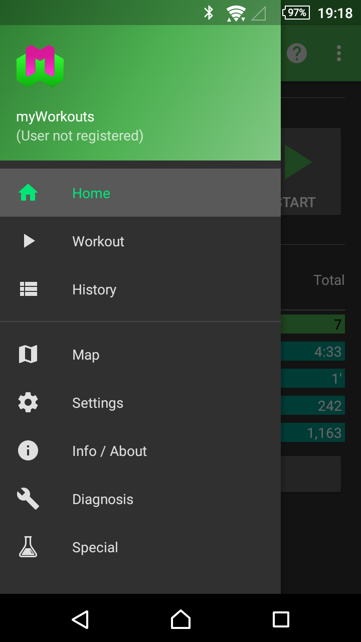
Home-Screen
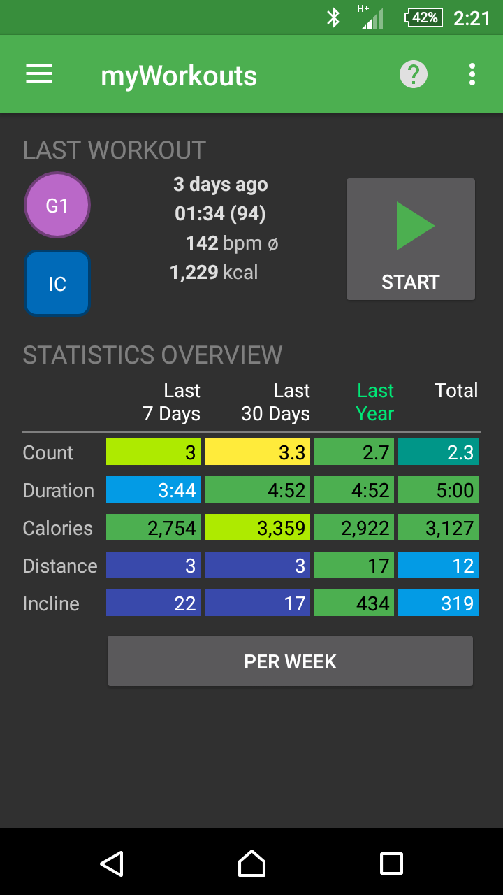
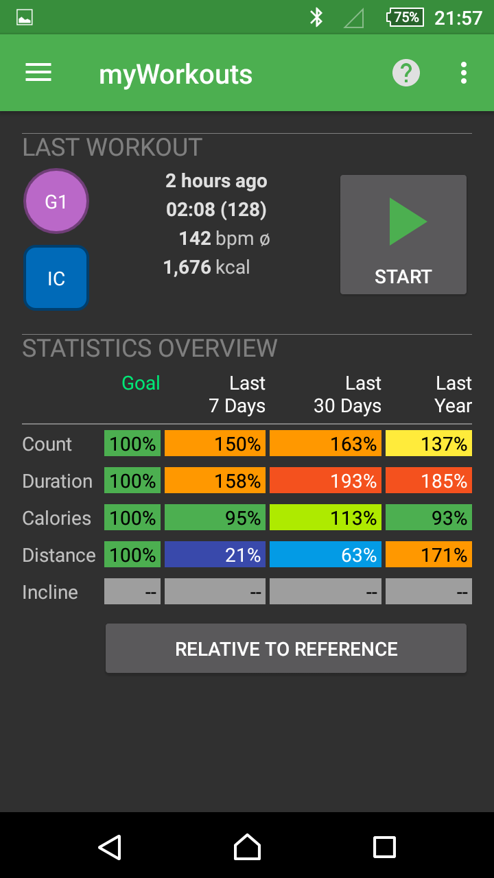
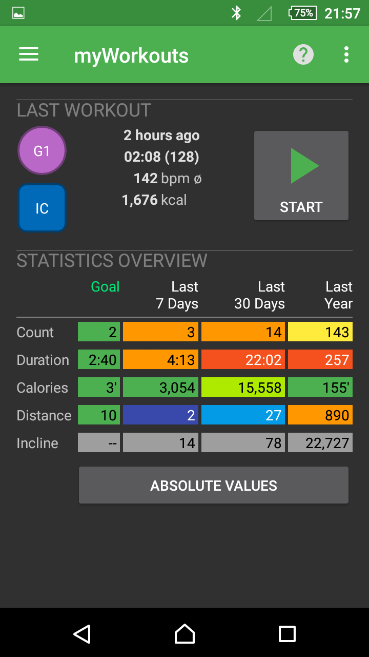
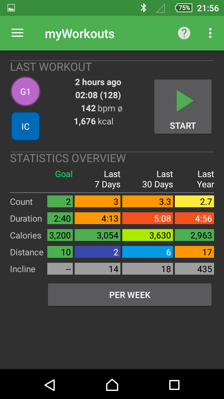
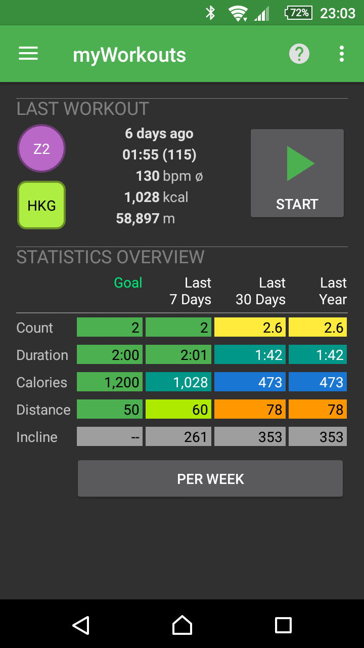
Last Workout / Running Workout
- Show some details about the last workout or information about the current workout
- Show workout details when tapping the info
- Start new training (green arrow)
Statistics
- Statistics shows numbers of workouts of the past:
Number, duration, calorie consumption, distance and altitude - Columns: Display of the periods (Note: it is not the calendar days or calendar months, but the time intervals returned by the current time).
- Specify comparison period by tapping columns or headings.
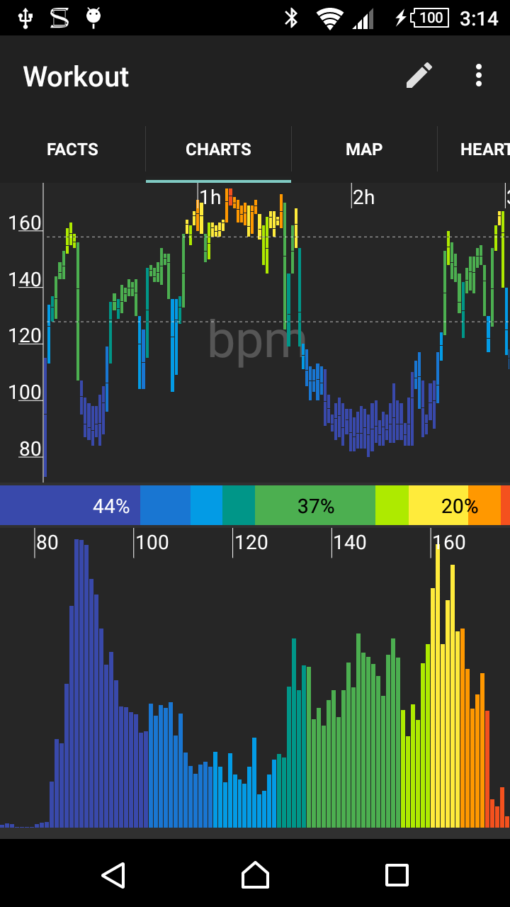
- Display the heading of the selected column in color. The selected column always represents the 100% and the remaining columns are color-coded.
- Periods in which relatively more or more intense activities have been reported, e.g. yellow or orange colored, periods with lower activity are colored light blue or blue.
- Switch display / display:
- Absolute numbers
- Per week (converted to 7 days)
- Percentage compared (figures per period in percent versus reference period)
Record training / workout
- Start new workout directly from the start page or from drawer menu.
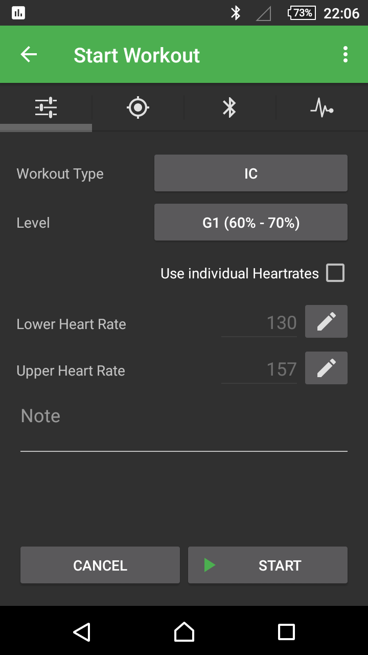
Workout settings
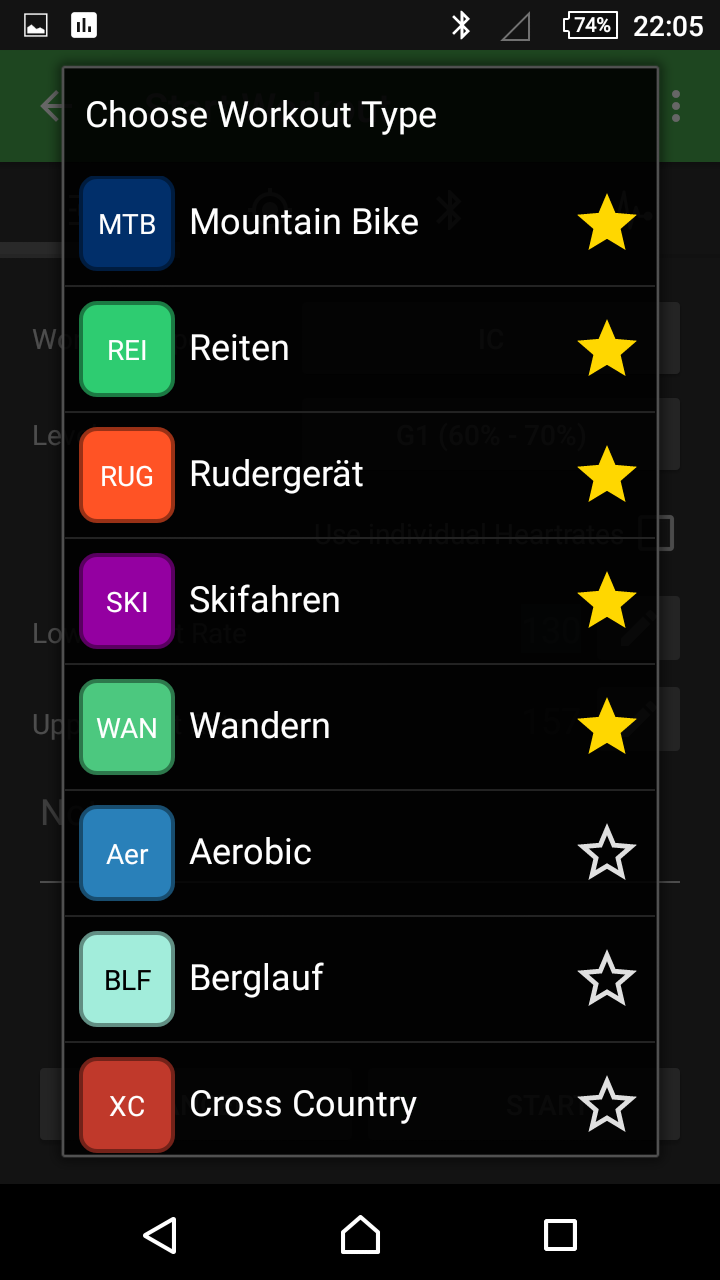
- Select sport (sort: first favorites, then other sports, by name)
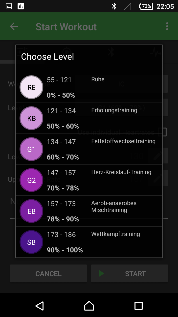
- Select the exercise intensity (pulse rate range)
- Select individual pulse rate range (heart rate from, to)
- Enter note / remark
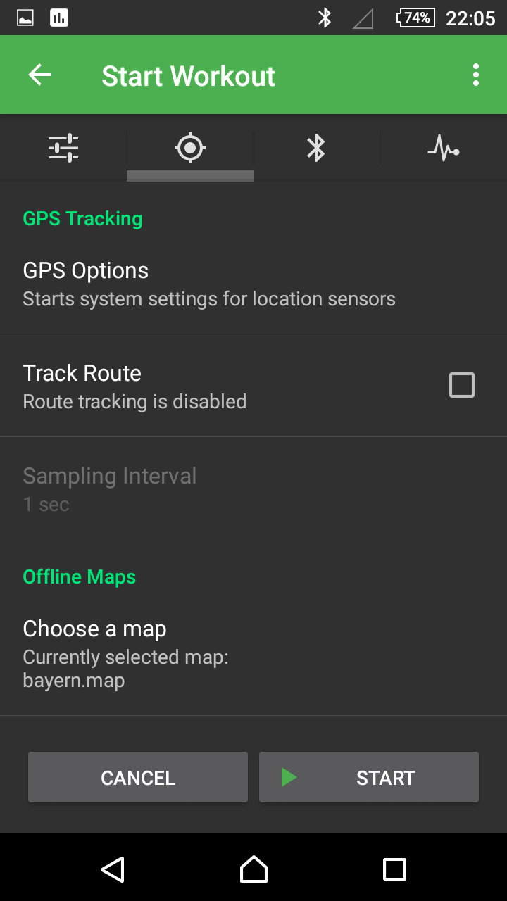
- Set GPS options
- Track route yes / no
- Set the time interval of the GPS points
- Select an offline map to match the tour
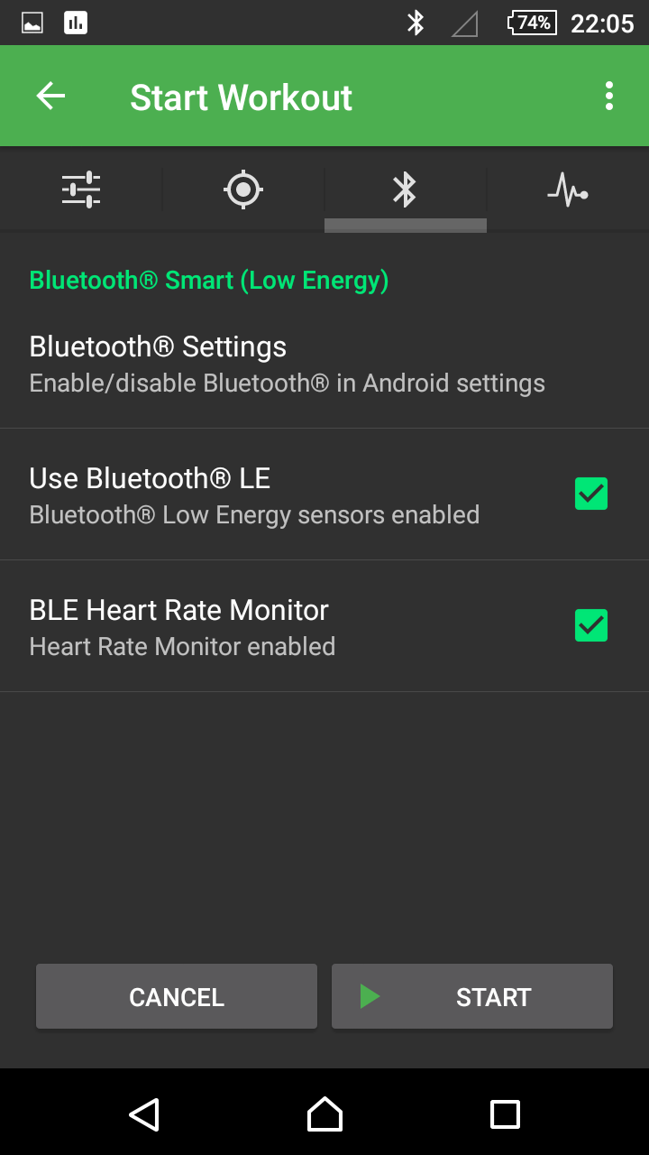
- Bluetooth ® Enable sensors yes / no
- Bluetooth LE Enable heart rate sensor
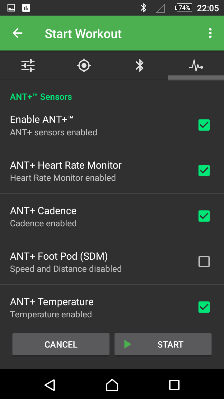
- ANT+™ Activate sensors yes / no
- ANT+ heart rate activate chest belt yes / no
- ANT+ cadence sensor yes / no
- ANT+ step rate and speed sensor (foot-pod) yes / no
- ANT+ temperature sensor yes / no
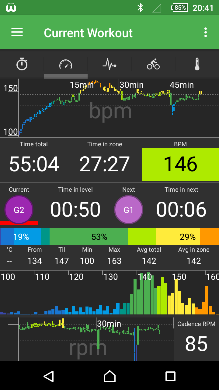
Display during workout / training
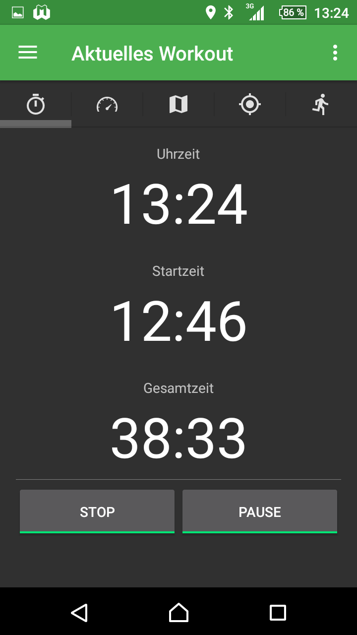
- Time, pause, continue, stop
- Current time
- Start time
- Total time (without breaks)
- Stop, pause, continue (Stop, Pause, Continue)
- Overview tachometer
- Depending on the sensors, certain parts are not visible or not filled
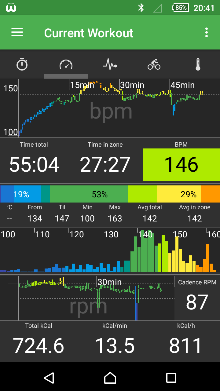
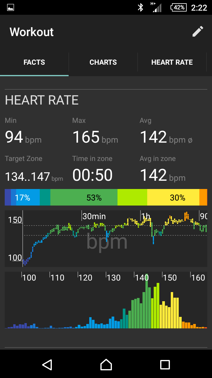
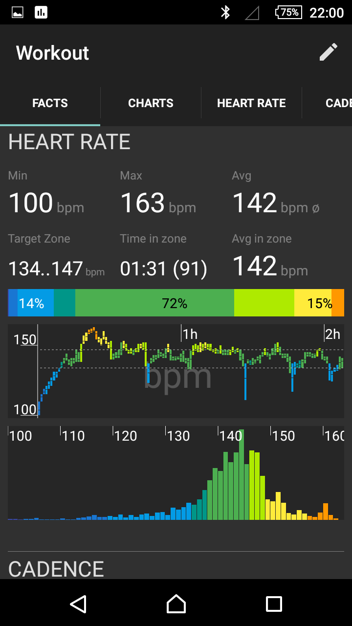
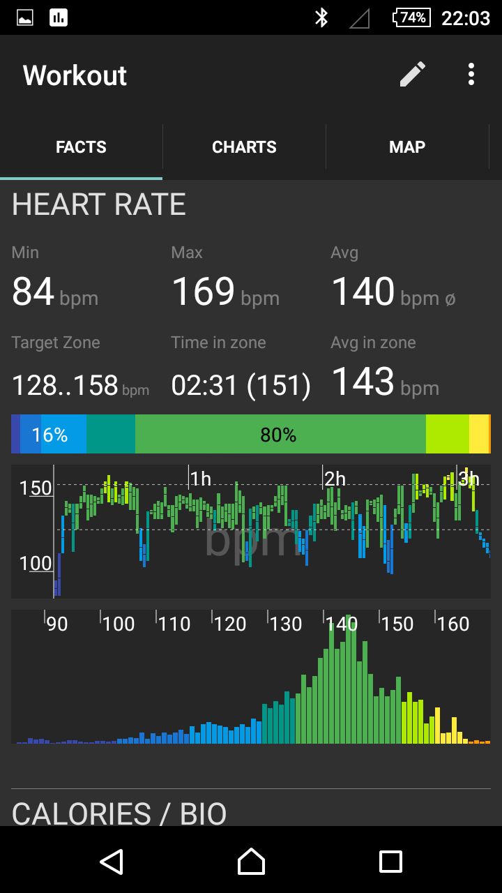
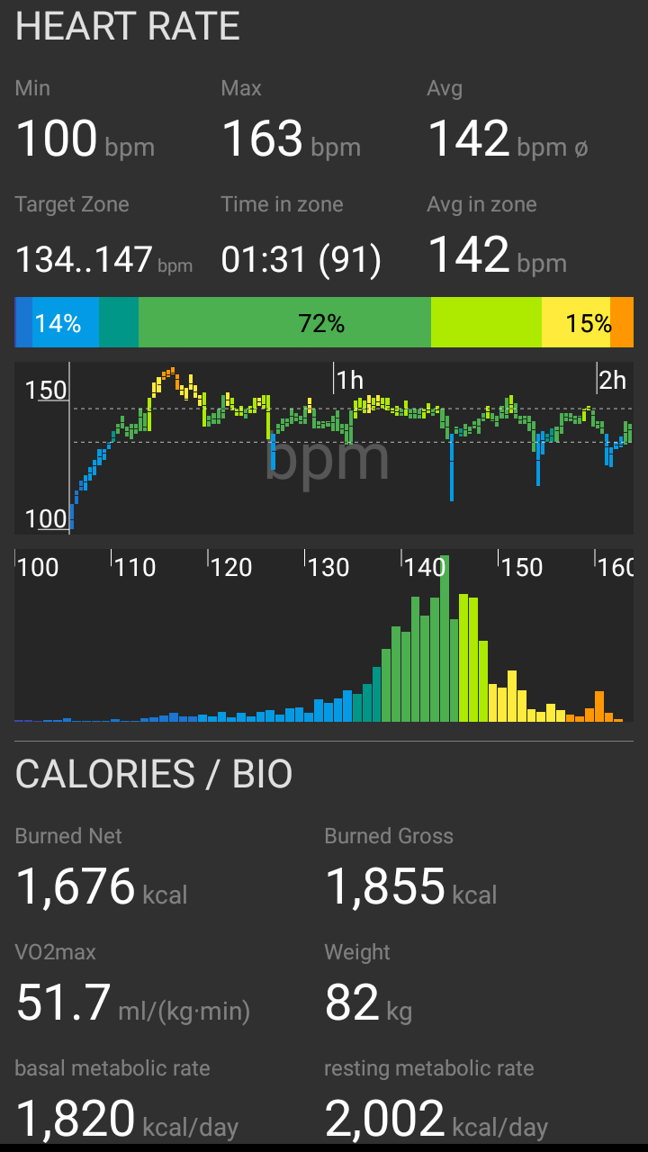
- Heart rate (possibility to zoom over pinch gesture, attach to last N minutes, display blocks with minimum value, maximum value and average value or display as bar graph only with average values)
- Display of total time, time in selected training intensity (heart rate range), display of current heart rate, color-coded whether under, in or via training intensity
- Display graphic with color coding and percentage values each time under, in or over heart rate range.
- Display of temperature, selected zone (heart rate from, to), measured minimum pulse and maximum pulse, average pulse total and average pulse in zone.
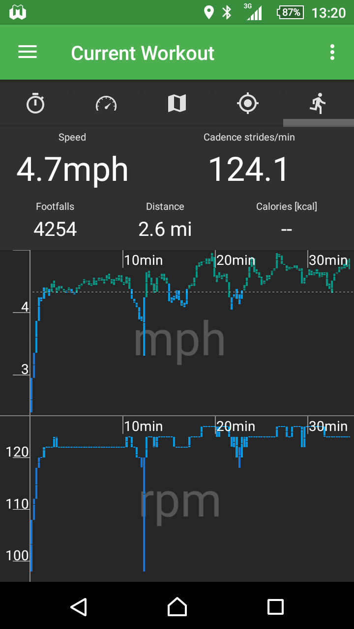
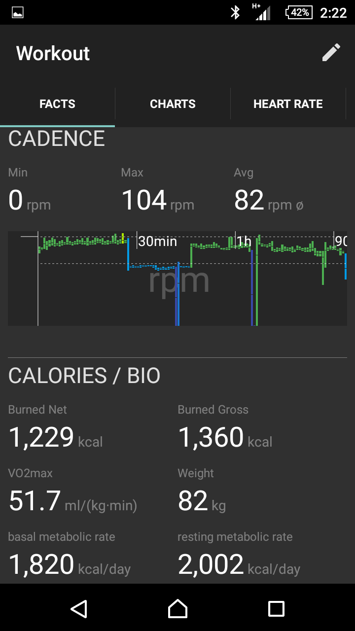
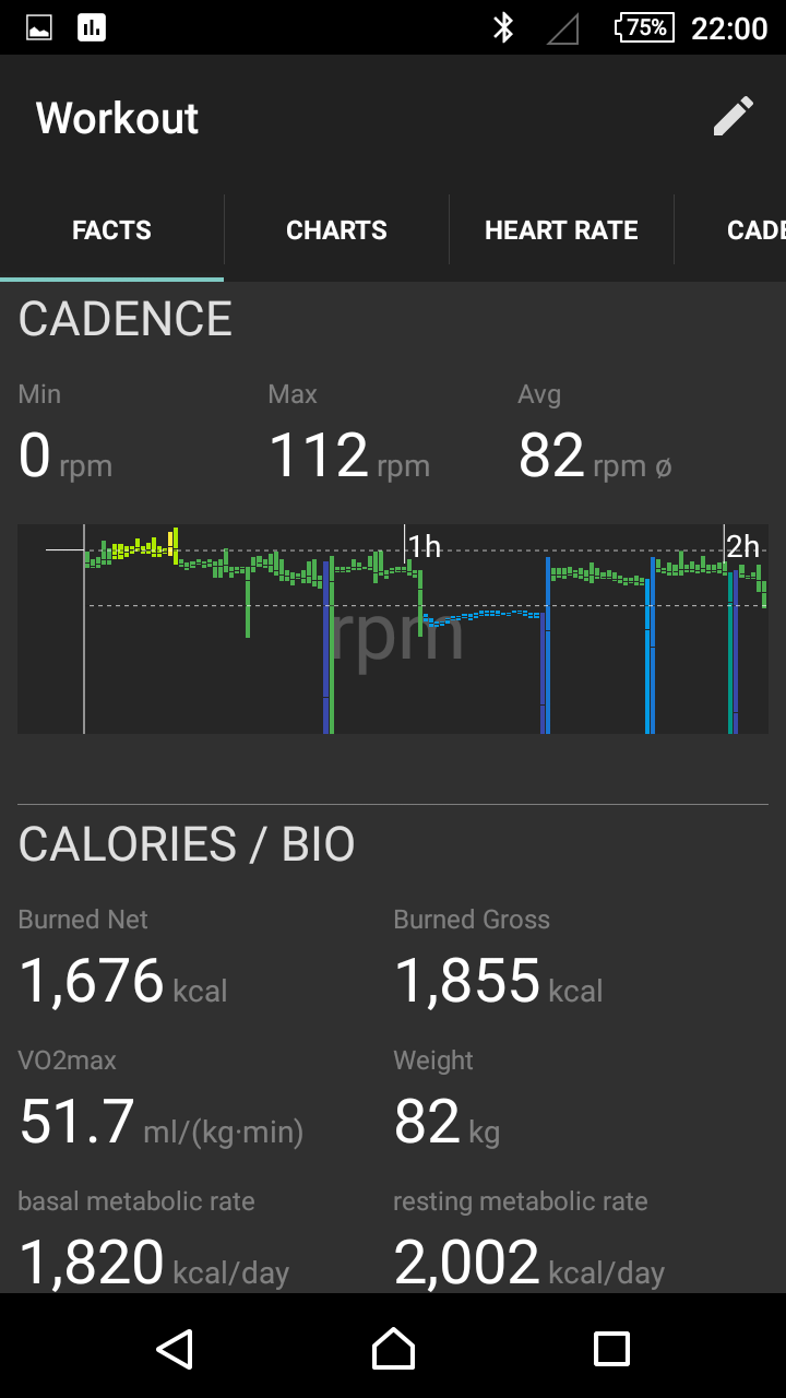
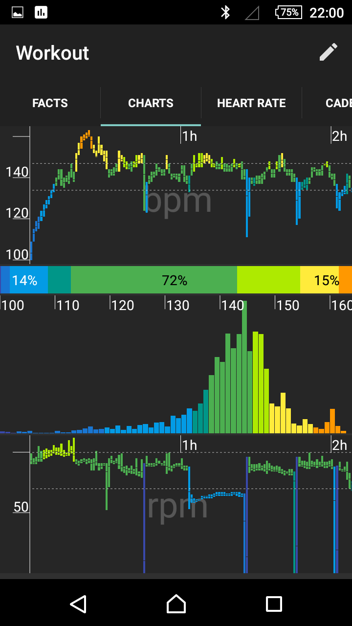
- Display of cadence as a diagram (see heart rate) and current cadence.
- Display of the course of the speed (measured via ANT+ step frequency sensor)
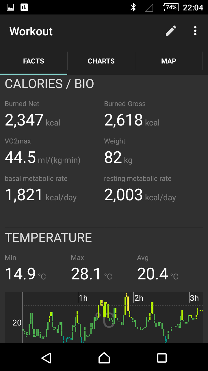
- Display of calories (kcal) total, currently calories per minute, currently calories per hour
- Display the current GPS position, GPS accuracy in meters, GPS altitude in meters
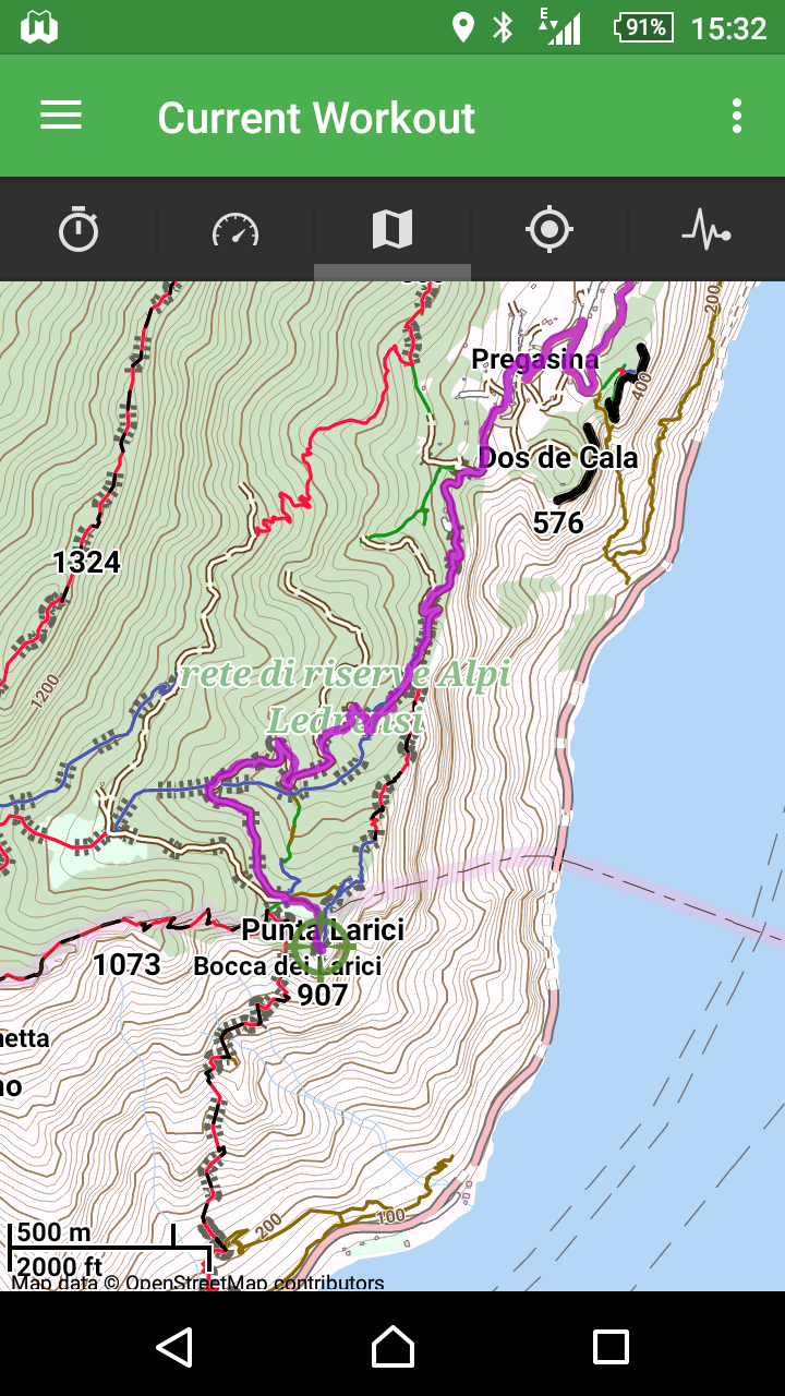
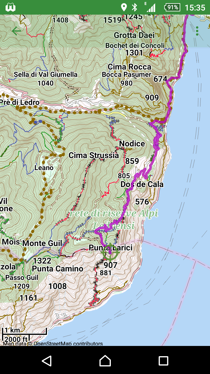
- Map (only if GPS recording is active)
- Display of map with north orientation (= top)
- Display of the offline map to the current GPS position (section automatically positioned)
- Map section can be changed via pinch gesture or (+) / (-) buttons (zoom function)
- Display of a crosshair over current GPS position or last known GPS position, color representation: green: determination current, red: determination is more than approx. 30 seconds back
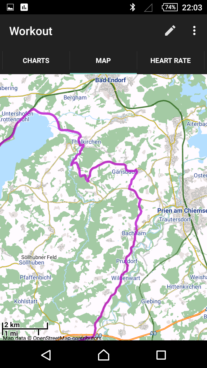
- Display of the track in color (magenta)
- Display of the selected route in color (green), only if route is selected
- Auto-Center function: can be switched on / off, switches off when the card is moved manually; When active: Map is automatically positioned with the current GPS position in the middle
- Display of a scale in meters / km and feet / miles
- Switch on / off slider; Use slider to navigate the track; Display of the relative speed as compared to the rest of the track (recognizable by the length of the highlighted track section)
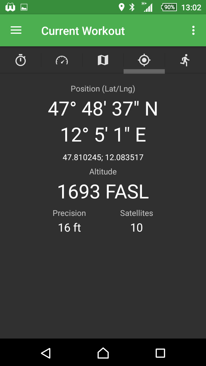
- View GPS data
- GPS position Show latitude / longitude in notation NN°MM’SS” N/S, NN°MM’SS” E/W
- Display GPS position in degrees with 6 decimal places
- Display of GPS altitude in meters above sea level
- Display of GPS accuracy in meters, display number of satellites whose signal is evaluated
- Heart Rate (Large View)
- Course of cadence (large view)
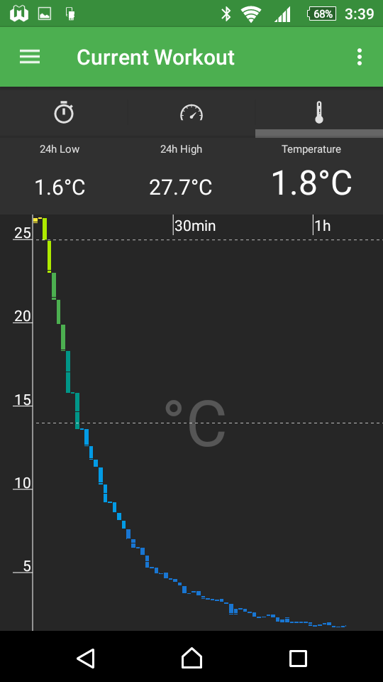
- Temperature history (large view) showing the current temperature, the 24-hour minimum value and the 24-hour maximum value
- View of step frequency, speed as graphs with gradient;
- Display the current sensor data of step frequency and speed
- Number of steps (step number)
- Calorie consumption (kcal) and measured distance;
- Some of these values are dependent on the respective sensor, e.g. The Suunto ANT+ step-frequency sensor (Foot-Pod) does not provide any calorie consumption.
Functions when recording
- Automatic storage of the workout at approx. 2-minute intervals and restoration in the case of a fall or shutdown of the device (battery empty).
- Tachometer remains active for certain screens (Screen-On); Intended for indoor sports, e.g. Treadmill or indoor cycling to keep track of data such as heart rate, cadence or calorie consumption during the workout.
- Watchdog function: Sensors are checked for function during training and tried to activate or connect at intervals when the connection (Bluetooth, ANT+, GPS receiver) is terminated.
- Diagnostic data can be displayed, which provide information about connection status, battery status of various sensors, connection interrupts, found sensors, etc.
Training logbook (History)
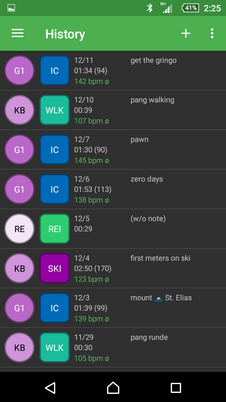

- Display of all workouts chronologically sorted
- Display of details:
- Training intensity, with abbreviation and color code
- Sport, with abbreviation and color code
- Date, time, average pulse, comment
- In transverse format additional display of calorie consumption, distance and altitude meter
- Subsequent recording of a workout (without sensor and GPS data, only facts)
- Calculation of calorie consumption using a manually acquired average pulse
- Recording of date / time, duration in h: mm: ss, intensity, sport, average pulse, comment
- Delete workouts
- Edit workouts
- If the training intensity is changed, the times in the zones are recalculated
- Subsequent setting of an individual pulse range
Analyze training / workout
- Comparison of training periods absolute, percentage or per week (see motivation)
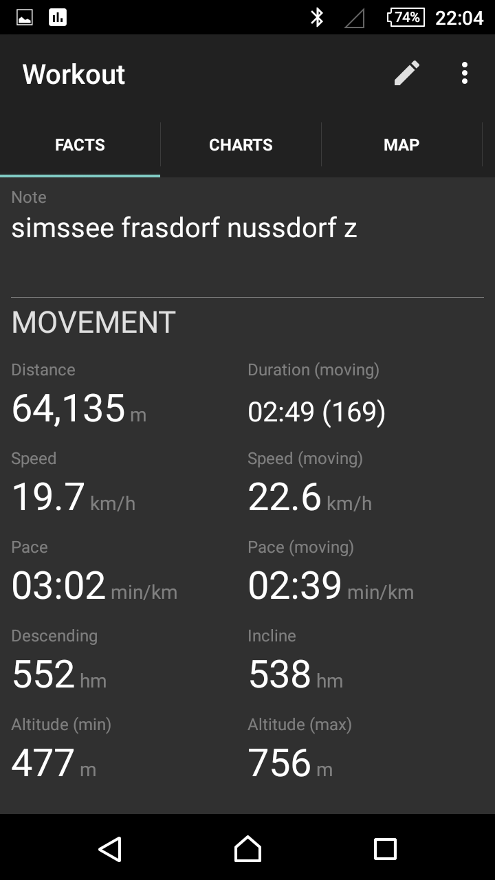
- View details and facts about the workout (e.g., average heart rate)
- Display of the sensor values (for example heart rate, cadence, step frequency, speed, barometric air pressure, temperature) with zoom function and switching between block line graphs with minimum, maximum and average values and bar graph with average values only.
- Display of the GPS track on offline map with zoom function and on / off slider.
- Export and share GPS track as a GPX file (for example, via mail, Dropbox®, …)
Orientate / Maps
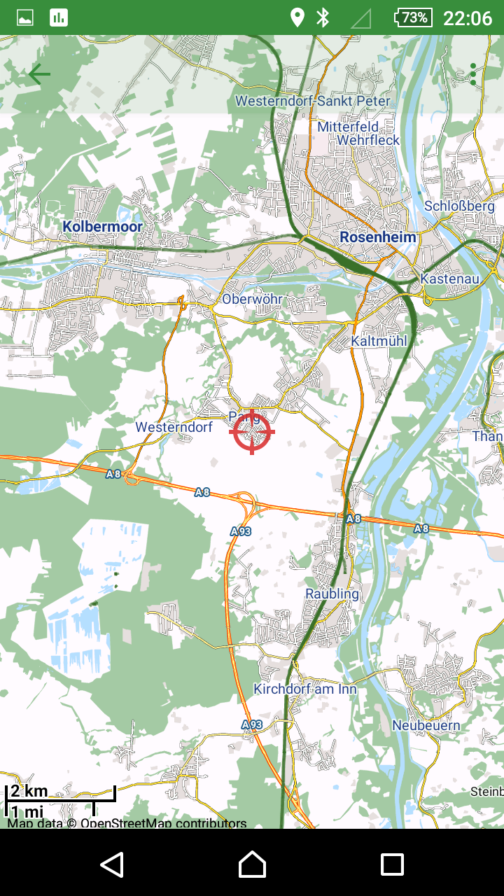
- Ad-hoc card (also without running workout)
- In full-screen mode display map, select GPS position for current position
- Change map (change to other map, thereby re-drawing the map)
- “Always Center” option moves the map automatically so that the current position is always in the middle.
- Automatic switching on and off of GPS use when opening and closing the card
- Show full-screen map while workout is in progress
- As ad-hoc map, but with representation of the running track (in color magenta)
- Display of the selected route (green color)
- Show Slider option; With Slider current track and read by the length of the green “worm” approximate speed
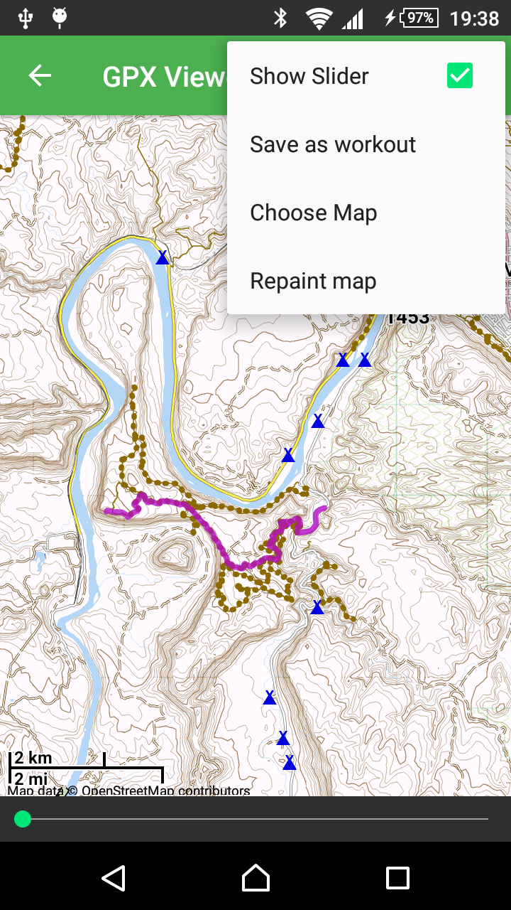
GPX-Viewer
- Opens GPX files and displays the GPX track on the map
- Calculates statistics on the GPX track (total time, time in motion, average speed, distance, altitude, speed in movement, minutes per kilometer, minutes per kilometer in motion)
- Save GPX track as a workout and insert it into history
Settings
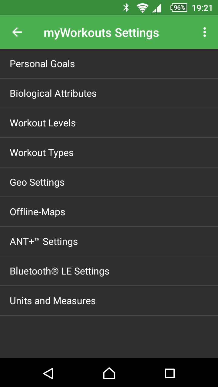
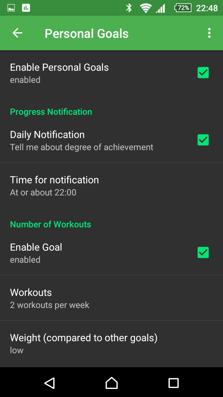
Goals
- Activate / deactivate goals
- Turn daily notification on or off
- Set the time for the daily notification
- Enter per goal:
- Activate goal yes / no
- Set number / measure per week
- Set weighting (not, low, normal, high), equals factor 0, 1, 2, 3
- Depending on the goal, some units (eg kilometers or miles)
- The following goals can be set and configured
- Number of workouts per week
- Total duration in minutes per week
- Calorie consumption (kCal per week)
- Distance (distance covered)
- Altitude (for mountain-climbers, for example mountain-bikes, skiers, ski-tours, cross-country skiers, cyclists, mountaineers)
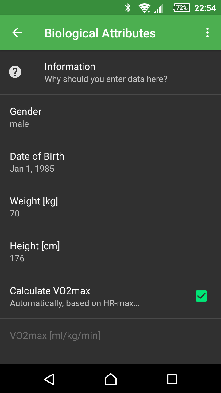
Biological data
- Record biological data:
- Gender
- Date of birth
- Weight
- Size
- VO2max (is calculated as standard pulse ranges and biological data)
The data is used for the calorie calculation.
- Switch between net and gross calories
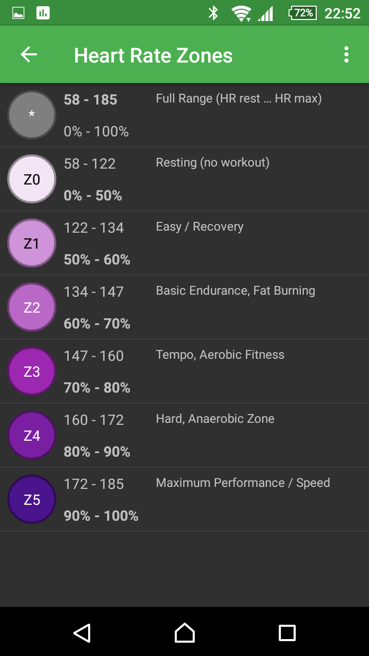
Training intensities (heart rate zones)
- 6 Define training intensities (lowest is considered rest, i.e., entries with this level are not counted as workout)
- Enter the minimum pulse (rest pulse) and maximum pulse
- Change name and abbreviation
- Define the pulse range, optionally as a percentage (measured at rest pulse and maximum pulse) or absolute
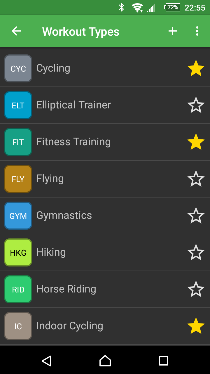
Sports / Workout types
- Define any number of sports
- Abbreviation, name, color (selection of 40 colors) and favorite status
- If the abbreviation is changed, automatically adjust all workouts accordingly
- Characterize certain sports as a favorite and only select favorites during the selection
- Add, change, delete sport
- Change abbreviation and optionally apply change to all relevant workouts
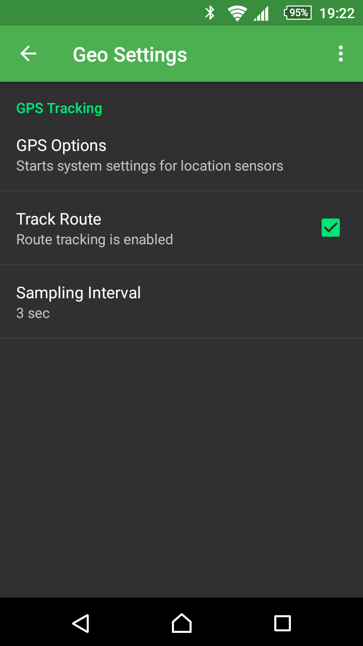
Geo-Settings
- Go to the GPS settings of the unit
- Record route on / off
- Set sampling interval (distance between GPS points), 1/2 second, 1, 2, 3, 5, 10, 15, 30, 60 seconds, 2, 3, 5, 10 minutes.
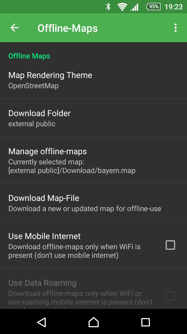
Offline-Maps Settings
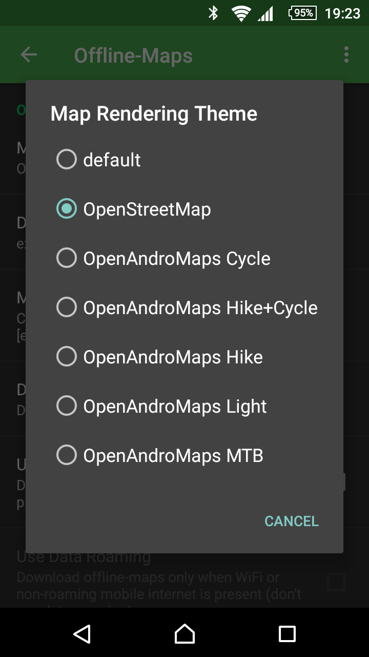
- Select rendering theme
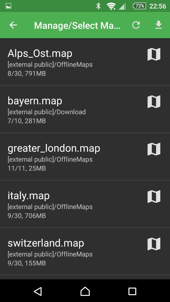
- Manage offline maps (list, view details, delete)
- Browse smartphone for Mapsforge offline maps
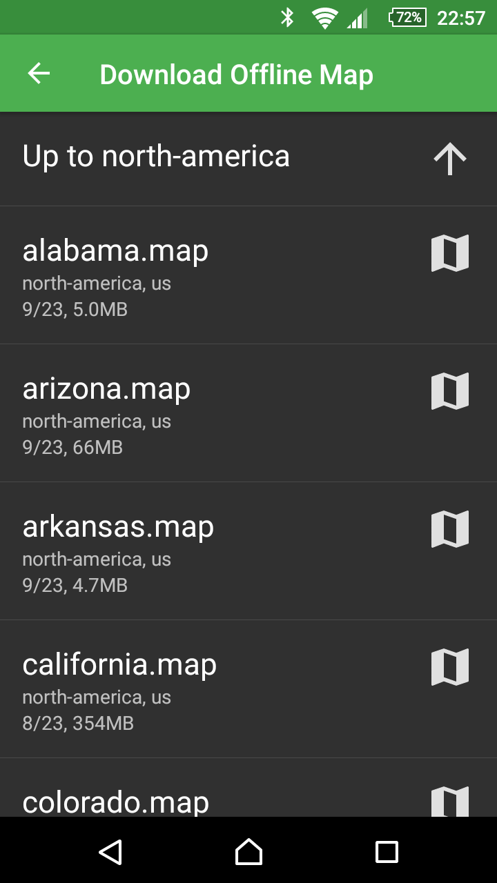
- Mapsforge Download Offline Maps (Australia, Oceania, North America, Central America, South America, Europe, World)
- Download in the background and only if connected to WiFi-network
- Activation that download is also allowed in the mobile network
- Activation that download is also allowed when roaming
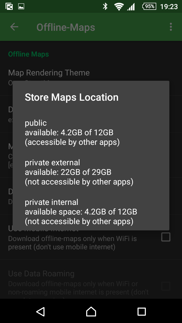
- Specify download directory and display available space (Internal-Public, Internal-Private, External-Private)
- Show all downloads (view Android system app)
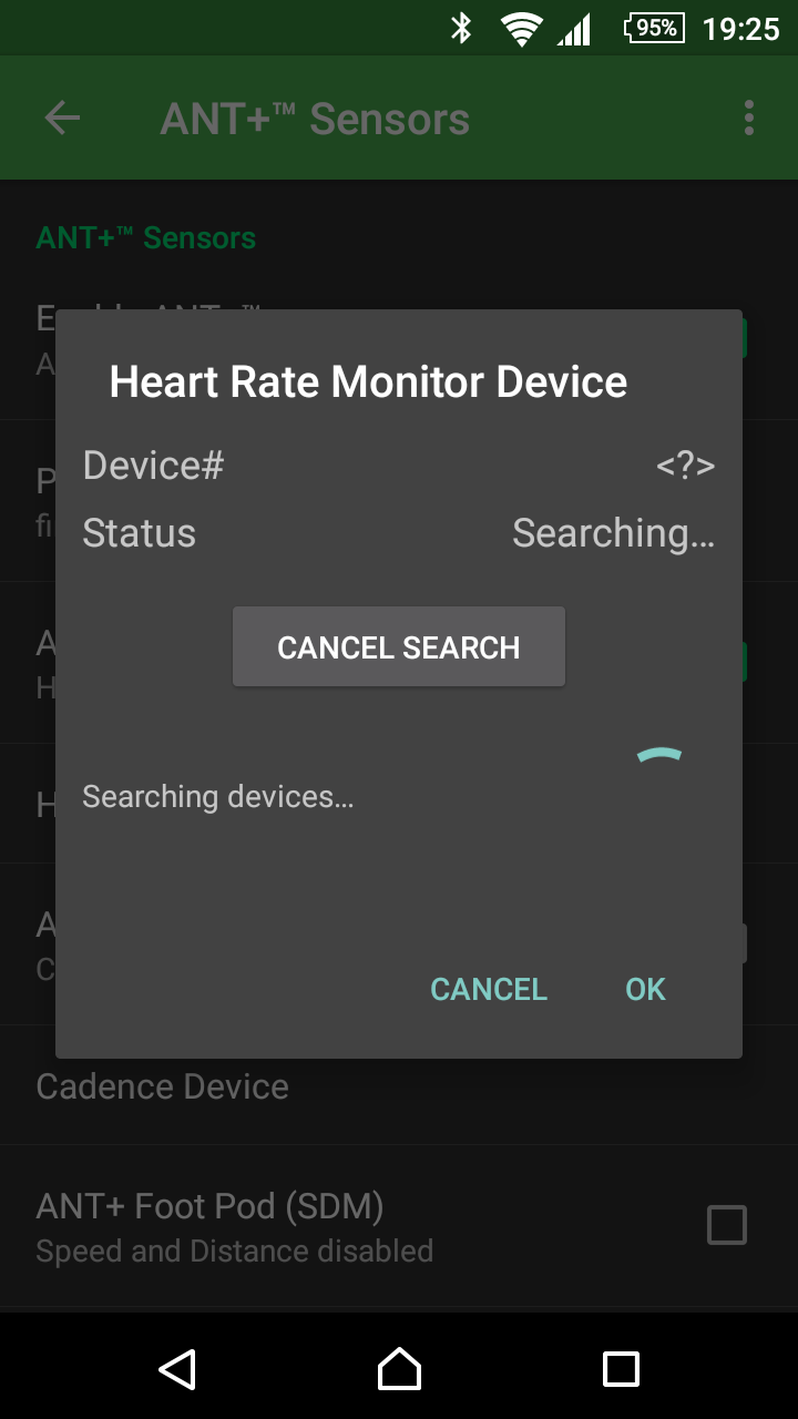
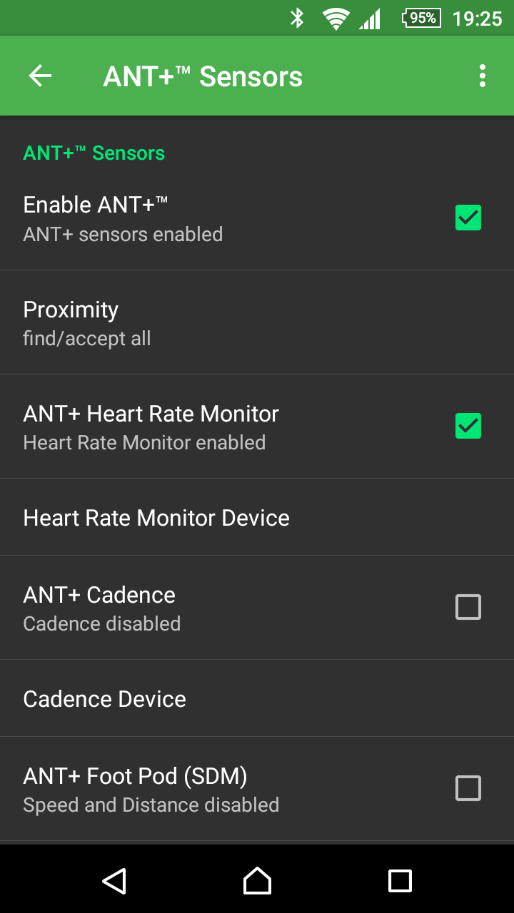
ANT+™ Settings
- activate/disable ANT+
- Detect the search sensitivity (proximity) for new sensors (all, farther away, away, middle, closer, very close)
- ANT+ heart rate sensor (pulse belt or heart rate monitor) activate yes / no; find / connect sensor
- ANT+ cadence sensor (cadence, pedal revolutions) activate yes / no; find / connect sensor
- ANT+ step frequency sensor (step counter, step sensor, food pod) activate yes / no; find / connect sensor
- ANT+ enable temperature sensor (ambient temperature) yes / no; find / connect sensor
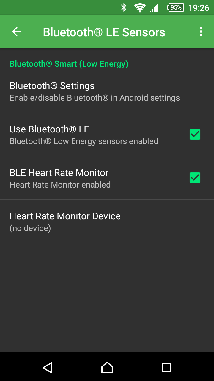
Bluetooth® Settings
- Go to Bluetooth settings on the system (e.g., to enable Bluetooth)
- Activate / deactivate Bluetooth sensors globally
- Bluetooth LE activate / deactivate the heart rate sensor
- Bluetooth LE heart rate sensor find / connect
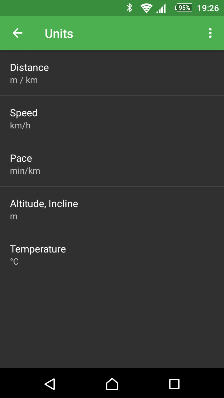
Unit settings
- Display distances in meters / kilometers or imperial units (miles, feet)
- Speed in km/h or miles/h
- Pace in minutes/km or minutes/mile
- Altitude / rise in meters or feet
- Temperature in °C or °F
Tracks
- Export and share your own GPX file tours
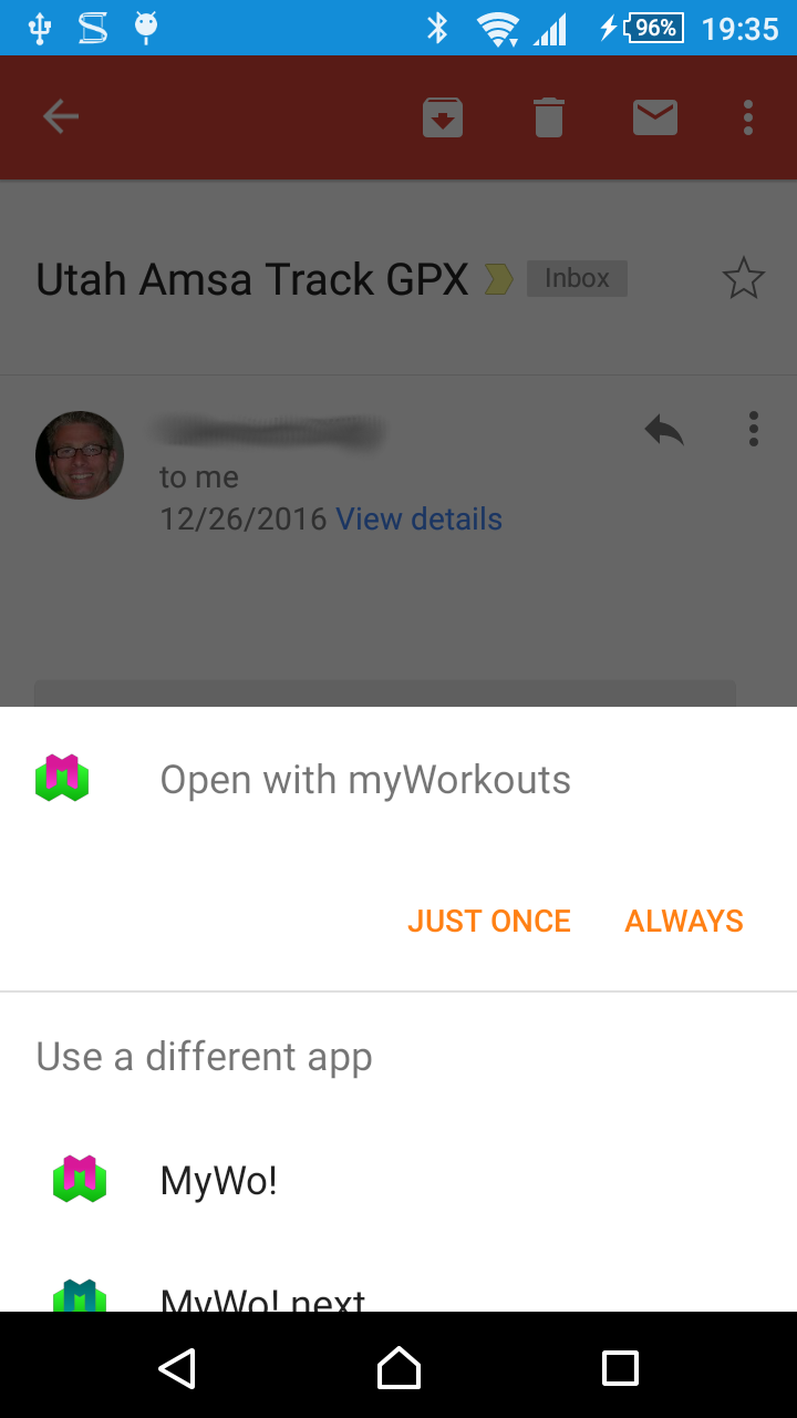
- View GPX files with the app and save as a workout
To do this, the file must be selected from another application (for example Gmail with GPX attachment, Dropbox, File Explorer) and myWorkouts as an app for opening. - Display statistics on imported GPX routes (route, altitude difference, time, speed, if applicable)
- Comparatively precise measurement of the altitude meter using the GPS altitude (+/- 10 percent deviation from altitude meter detection by barometric tools such as Garmin Dakota 20).
Motivation
- Show last workout with some key data, including relative time (e.g., “2 days ago”) on Home page
- Overview statistics on home page
- Comparison of the “goals”, “last 7 days”, “last 30 days”, “last year”, and “total” (on narrow devices only 4 columns, deactivating destinations without the “goals” column)
- Switching the display between “Percentage”, “Per Week”, “Absolute”
- Display of “number of workouts”, “duration”, “distance”, “calories” and “altimeter”
- Daily notification: percentage of goals achieved; Time adjustable
System, Security, Maintenance
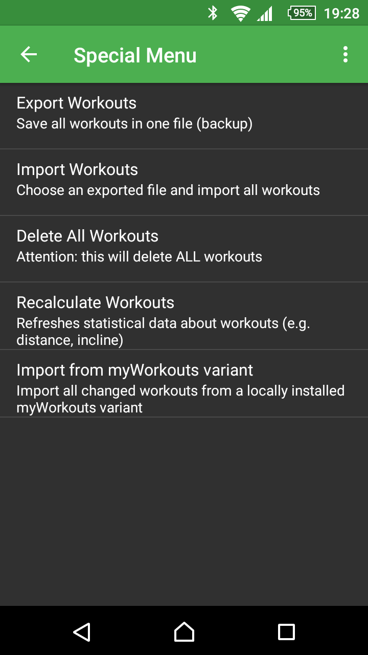
- Delete all workouts
- Export all workouts in a compressed file (for later import)
- Import exported workouts from compressed file
- Move the app to SD card
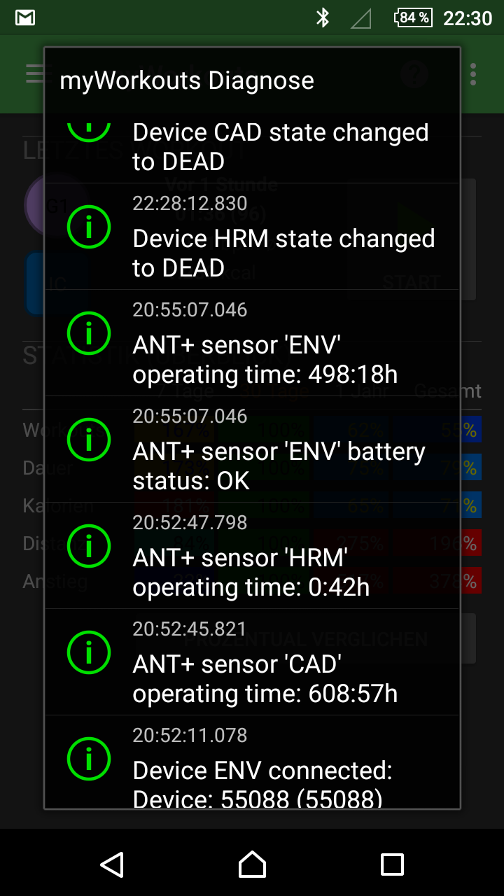
- Display diagnostic data (GPS status, ANT + sensors status, ANT battery status, Bluetooth connectivity, status of import and export of training data)
Help
- Provide context-related help and information, partially with background information on sports and health
Languages
- German (completely available, except open source licenses)
- English (some help texts not yet available)
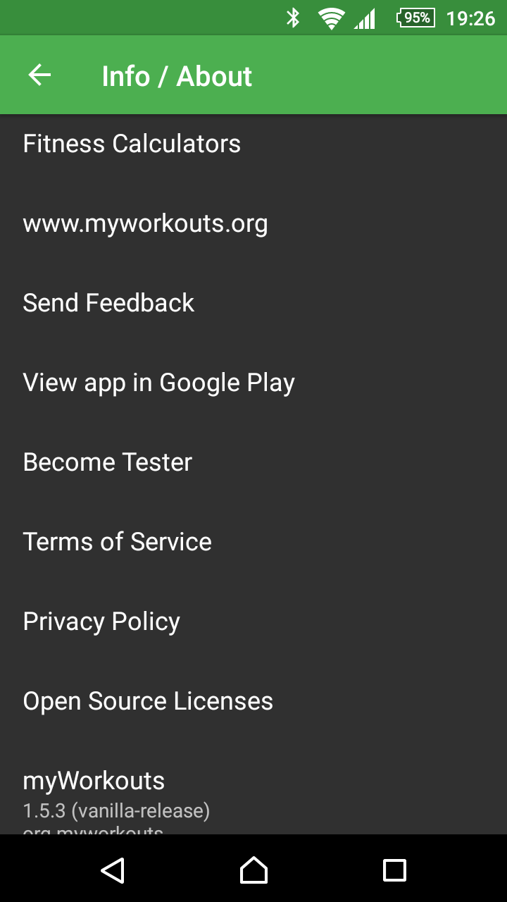
Information
- Link to various fitness calculations (heart rate, calorie consumption, VO2max)
- Link to <www.myworkouts.org>
- Send feedback as an email from the app
- View app on Google Play
- Information for testers
- Terms of Use, Privacy Policy
- Open source licenses
- Display version number, application ID, build date, and update date / time
Is something missing?
Do you miss certain features you might know from other apps? - Please write an email to <mailto: info@workouts.org>.
It would help if you list individual features. We often get requests, which we can not meet and in which also little flow into our TODO feature list, e.g. “Everything Oruxmaps can do, plus offline navigation with turn-by-turn like komoot and then still Strava segments, but better.”
Planned Features
Following features are already on our list:
- Other translations (depending on demand, maybe Italian, Spanish)
- Adjust the speedometer itself
- Manage tours / routes (separate from your own workouts)
myWorkouts next
The Android app myWorkouts next is a non-public app, but anyone can use it as a tester to register (in the app go to “Info / About …” -> “Become tester”).
This “next” version has all the features of the standard version, but it also has features that are only released in later versions of myWorkouts and may be accessible only when buying in-app products.
Maintenance
- Determine a Google account to log on to the myWorkouts server
- Synchronize workouts with myWorkouts servers, i. The workouts are automatically synchronized in the case of several devices (for example, the phone and the tablet).
- Local synchronization between standard and next versions, allowing you to easily switch between versions.
Sensors
- ANT+ weight scale (Determination of weight, body fat content, water content, bone mass, …)
Tachometer
- Display of current level (training intensity) and tendency to change to other levels
- Displays the time in the current level
SOS / Live-Tracking
- Send a strongly compressed track section at intervals to the number of a partner / friend by SMS
- Setting possibility: sending frequency, minimum distance to the last transmission
Feedback
We are grateful for any feedback (positive and negative) - please write us: <mailto: info@myworkouts.org>
Note
All mentioned names (e.g., Google Play, Android, ANT+, Bluetooth, Garmin, Suunto, Strava, komoot, …) are registered trademarks of their respective owners or manufacturers.